We seeking consultant services for an alternatives analysis and conceptual design for the Mill Creek channel near College Place, WA. Design alternatives will be developed with stakeholder input and review. Data collected during the project will help inform alternatives. The design alternatives will address a new fish passage barrier at the site, a fishway with maintenance needs, bridge and road infrastructure, incised channel conditions, and the outlet of a flood control channel. The completed project will provide an alternatives assessment report, a preferred alternative, and conceptual level plans of the preferred alternative.
REQUEST FOR PROPOSAL (click here) RFP is closed
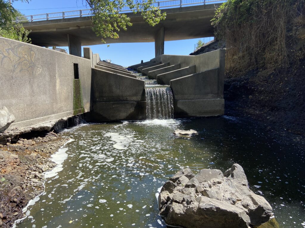
In February 2020, the flood of record in the Walla Walla watershed created a fish passage barrier at the fishway. The flood control channel operated at capacity (~4,000 cfs) for hours. During the flood flows, the streambed was scoured and downcut at the fishway below Gose Street bridge, resulting in a jump height of approximately five feet for fish trying to enter the fishway.
The co-managers, Confederated Tribes of the Umatilla Indian Reservation and Washington Department of Fish and Wildlife, were able to mobilize an emergency remedy in October 2020. The emergency repair built two weirs from ecology blocks, which breaks the five-foot jump into two smaller jumps. This solution was intended to be a short-term fix, not designed to withstand flow at the channel’s capacity. Because the design had to be implemented quickly, there was not time to design a durable, long-lived solution.
The situation is complicated by the footings of the Gose Street bridge in the channel. One engineer inspecting the channel scour was of the opinion that the fishway prevented the bridge from washing out, though the county public works department noted no concerns following their post-flood inspection. Any long-term fix here must include the long term stability of bridge.
While we can envision a few design alternatives to address the project goal, these are not based on any data. Therefore, we believe an assessment process in which relevant data is collected will lead to informed alternatives based on data. We have chosen to develop the preferred alternative to the conceptual level because it poses the lowest level of risk to TSS, landowners, and stakeholders given the lack of lack of data for the site, and the likelihood that the preferred alternative has yet to be identified.